By early January 2026, a rainy December had left the Pacific Northwest with an awkward problem: too little snow. Precipitation had exceeded normal levels, yet the region’s snow drought had intensified.
Much of that moisture fell as rain, illustrating how warmth changes mountain snow. Water was arriving without building the same frozen reserve for the months ahead.
That happened last winter. It offers a useful distinction as a strengthening El Niño raises expectations for winter 2026–27: a season can deliver plenty of precipitation and still disappoint people counting on snow.
In its September 10 forecast, NOAA put the probability of a very strong El Niño during fall and winter above 90%. It also estimated a 75% chance that the event’s October–December strength would exceed earlier El Niños in its comparison record, which begins in 1950.
Those are substantial odds. They describe a possible record in the tropical Pacific, however, rather than a prediction of record snowfall, rainfall or cold across the United States.
El Niño’s strength measures one part of the system that produces a winter. Its local consequences depend on what happens between the ocean and the ground.
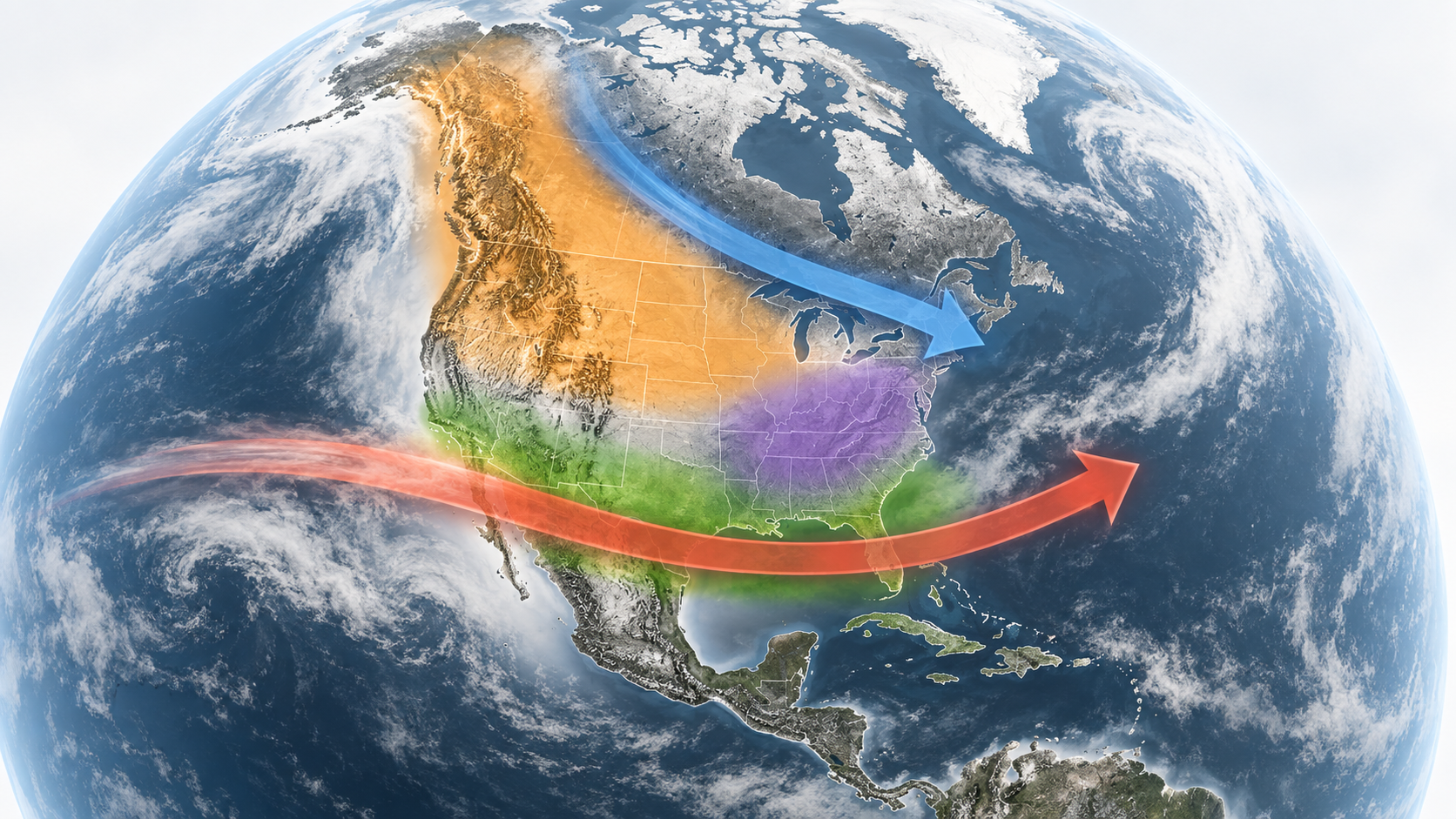
The connection begins with winds along the equator. Under normal conditions, trade winds push warm surface water toward the western Pacific. During El Niño, those winds weaken, and warmer water extends farther east. Changes in tropical rainfall and atmospheric circulation can then alter the Pacific jet stream and the routes storms take toward North America.
That helps explain the familiar El Niño pattern: a warmer northern United States and wetter conditions across much of the South. The pattern is useful because it shifts the odds. It doesn’t dictate every storm.
Even the temperature measurement needs some care. NOAA’s Relative Oceanic Niño Index compares anomalies in a particular equatorial Pacific region with temperature anomalies across the broader tropics. It helps separate the regional signal from widespread tropical warming. A large index value isn’t a temperature forecast for an American city, or a measurement of the entire Pacific warming by that amount.
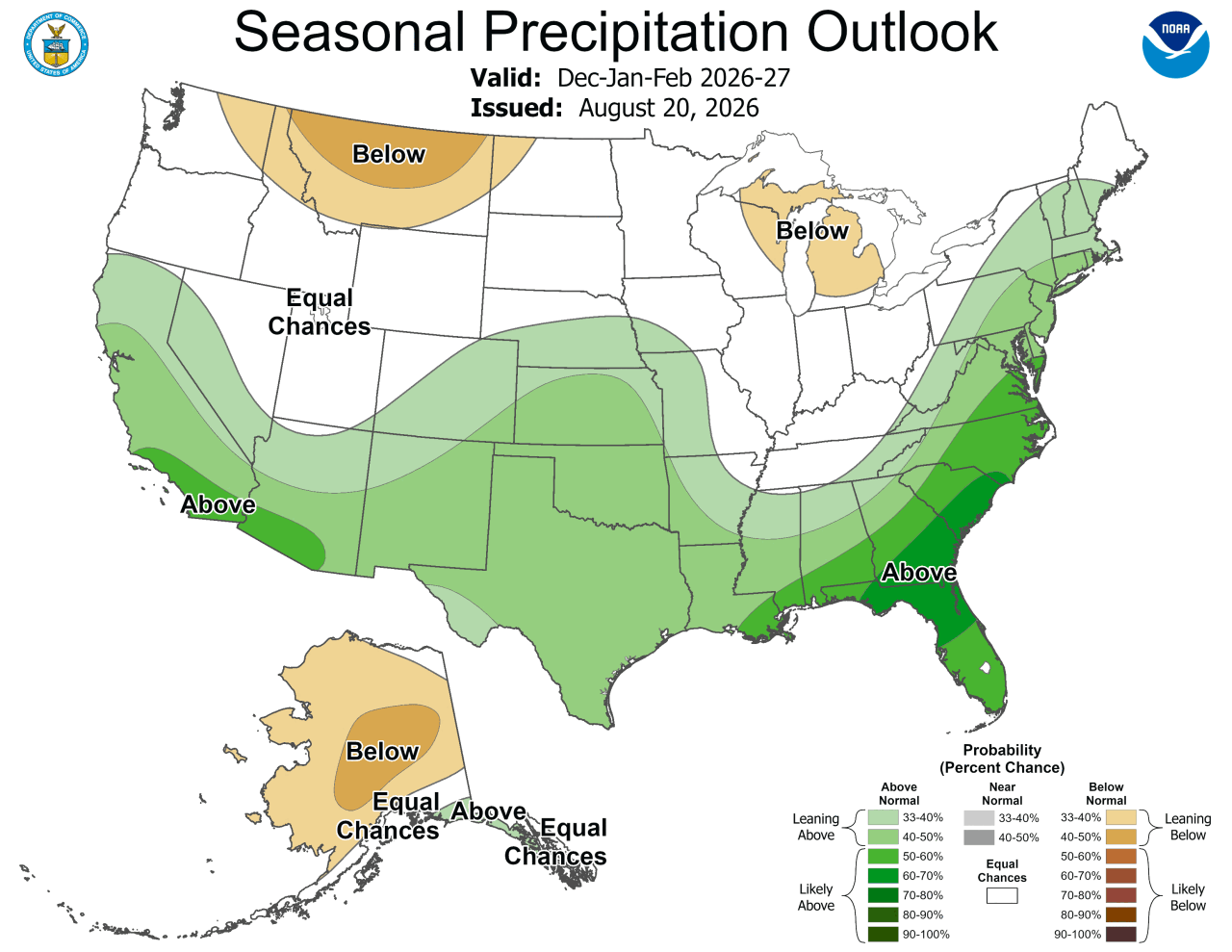
The U.S. seasonal outlook available as of September 12, issued on August 20, reflects more than El Niño alone. It favors a warmer winter across the northern tier, from the Pacific Northwest to the Northeast. Wetter conditions are favored across the Southeast, with the wet signal expanding along the East Coast into winter.
California and southern Arizona also have increased odds of a wet winter. But the Southeast isn’t simply assigned the colder conditions often shown on textbook El Niño maps. Forecasters favor near-normal temperatures there in several winter periods because recent warming trends work against El Niño’s usual cooling influence.
The differences matter. The outlook also avoids treating the entire Pacific Northwest as uniformly dry, keeping that winter signal inland rather than extending it to the coast.
These forecasts describe probabilities over a month or season. A 40% chance of above-normal precipitation doesn’t mean 40% more rain. Nor does an area marked equal chances have a promise of ordinary weather. It means no category is favored. A wet outlook doesn’t specify whether the precipitation will be rain or snow.
The storms still have to arrive
California offers a particularly useful test of the gap between a seasonal pattern and the weather that actually develops.
In a 2025 study in Climate Dynamics, researchers examined wet seasons that contradicted the expected El Niño–La Niña pattern in California and the Southwest. Seasons ending in 2011, 2017 and 2023 were unexpectedly wet during La Niña, the phase generally associated with drier conditions in that region.
Atmospheric rivers helped explain the discrepancy. These concentrated corridors transport water vapor through the atmosphere and can supply major storms. Unusually active atmospheric rivers contributed to wet conditions in those La Niña seasons. Some El Niño seasons that disappointed on precipitation had too little atmospheric-river activity instead.
The researchers found that this Pacific cycle had a generally weaker relationship with precipitation from atmospheric rivers than with precipitation from other storms. The connection varied by location, with stronger links in parts of the desert Southwest.
That leaves an important forecasting problem. The tropical Pacific can provide a useful seasonal signal without revealing which powerful storms will reach a particular coastline.
“Atmospheric river activity in California cannot currently be predicted seasons ahead,” Scripps climate scientist Alexander Gershunov said in an August 19, 2026 university Q&A.
That limitation doesn’t make El Niño irrelevant. It means the storms capable of changing a region’s water outlook still require closer-range forecasts. An exceptionally strong ocean signal doesn’t remove that need.
For the West, another uncertainty begins when the moisture reaches the mountains.
Snow drought can develop because too little precipitation falls. It can also develop during relatively wet conditions, when warmth sends more precipitation down as rain or melts the snow early. NOAA distinguishes these as dry and warm snow drought.
Snowpack stores water through winter and releases it as temperatures rise. Rain and early melt can change when water reaches rivers and reservoirs, even when the total precipitation looks reassuring. That timing matters for water supplies, ecosystems and recreation.

The connection is visible in Yosemite’s mountains and waterfalls. Yosemite Falls depends almost entirely on snowmelt. Its flow reflects both the snow accumulated in the high country and the timing of the thaw, according to the National Park Service. A mountain’s winter can remain visible in its waterways long after the last storm.
None of this establishes that winter 2026–27 will leave the West short of snow. The Pacific Northwest’s rainy December was a previous season’s observation, not evidence that the coming El Niño has already produced a snow drought.
It does explain why a confident El Niño forecast can coexist with unanswered questions about local winter conditions. The seasonal outlook offers a starting point. Individual storm forecasts and measurements of the accumulating snowpack will show what the mountains actually receive and retain.
For communities that depend on mountain water, the consequential number next spring may be neither El Niño’s peak strength nor the winter’s total rainfall. It may be how much water is still waiting uphill when the storms stop.


Leave a comment